
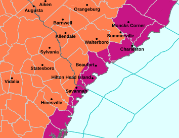
Heat index could reach 115 Monday and climb as high as 117 Tuesday as dangerous heat continues across the Lowcountry
By Delayna Earley
The Island News
Another round of dangerous heat has settled over Beaufort County, with temperatures pushing 100 degrees and heat index values climbing well above 110 as the Lowcountry enters another week of extreme heat.
The National Weather Service in Charleston has placed Beaufort and portions of southeast South Carolina and southeast Georgia under an Extreme Heat Warning from 11 a.m. to 8 p.m. Monday, Aug. 17.
Heat index values between 112 and 115 degrees are expected within the warning area Monday.
And Tuesday could be even hotter.
An Extreme Heat Watch remains in effect for Tuesday, when heat index values between 113 and 117 degrees are possible.
The temperature in Beaufort is expected to reach about 98 degrees Monday before climbing to around 100 degrees Tuesday. Hilton Head Island is expected to reach about 96 degrees Monday and 99 degrees Tuesday.
The latest round of warnings follows a prolonged stretch of oppressive heat across the Lowcountry last week, when Beaufort County was repeatedly placed under heat advisories and extreme heat warnings and overnight temperatures offered little relief.
The National Weather Service said the heat will continue through the week, with temperatures in some areas potentially reaching or exceeding 100 degrees. Record heat is possible during the hottest portion of the stretch.
Chances for afternoon showers and thunderstorms will also increase, with storms potentially providing temporary relief from the heat in some areas. Strong thunderstorms could develop during the week as hot and humid conditions persist.
What do the different heat alerts mean?
With Beaufort County experiencing heat advisories, watches and warnings during the prolonged stretch of hot weather, the terms indicate both the severity of the expected heat and how certain forecasters are that dangerous conditions will occur.
A Heat Advisory is issued when hot temperatures and high humidity are expected to create conditions that could cause heat-related illnesses. For the National Weather Service Charleston forecast area, an advisory is generally issued when the heat index is expected to reach 108 to 112 degrees for at least two hours.
An Extreme Heat Watch means dangerously hot conditions are possible, but there is still some uncertainty about whether or exactly when warning-level conditions will occur. Watches are generally issued in advance to give residents time to prepare.
An Extreme Heat Warning means dangerously hot conditions are expected or already occurring and people should take action to protect themselves. In the Charleston forecast area, a warning is generally issued when the heat index is expected to reach 113 degrees or higher for at least two hours.
That means Monday’s Extreme Heat Warning represents a more immediate threat than the Extreme Heat Watch currently in place for Tuesday. If forecasters become more confident that Tuesday will reach warning criteria, the watch could be upgraded to a warning.
Heat can turn deadly
The prolonged heat has prompted the South Carolina Department of Public Health to urge residents to take the threat of heat-related illnesses seriously.
“Forecasts are calling for temperatures around 100 degrees, with even higher heat indexes,” Dr. Brannon Traxler, acting DPH director, said in a statement Friday. “We urge everyone to take precautions to help protect themselves and their families from the extreme heat.”
Traxler said heat-related illnesses can result in serious injury and even death.
From May through September 2024, there were 2,014 emergency department visits and 246 hospitalizations for heat-related illnesses in South Carolina, according to DPH.
Fifteen people died from exposure to excessive natural heat in South Carolina in 2023, the most recent year for which mortality data is available.
Infants and children, pregnant women and older adults are among those at increased risk of heat-related illness. DPH also recommends checking on family members, friends and neighbors, particularly those who live alone or have chronic medical conditions.
DPH identifies three stages of heat-related illness: heat cramps, heat exhaustion and heat stroke.
Heat cramps can cause painful muscle spasms, often in the legs or abdomen. Someone experiencing heat cramps should move to a cool location, drink water and cool or gently stretch the affected muscles.
Signs of heat exhaustion can include cool or clammy skin, headache, nausea, weakness and dizziness. Anyone experiencing those symptoms should stop what they are doing, move to a cool location and drink fluids.
Heat stroke is the most serious heat-related illness and is a life-threatening emergency. Signs can include red, hot and dry skin, confusion, loss of consciousness, a rapid weak pulse and rapid shallow breathing.
Anyone suspected of suffering from heat stroke should receive immediate medical attention. DPH advises calling 911 and beginning to cool the person while waiting for emergency responders by moving them into the shade or indoors, removing excess clothing and using water, ice packs or cold wet towels.
Local governments urge residents to take precautions
The Town of Port Royal urged residents Monday to stay hydrated, spend as much time as possible in air-conditioned spaces, avoid prolonged sun exposure and strenuous outdoor activity and check on relatives, neighbors and older adults who may be particularly vulnerable to extreme heat.
The town also reminded residents never to leave children or pets unattended in a vehicle and warned that interior temperatures can become deadly within minutes.
Beaufort County is encouraging residents who need a break from the heat to visit county recreation centers and libraries to stay safe and cool.
Places to cool off
Beaufort County has identified eight county facilities residents can visit to get out of the heat during regular operating hours.
The Burton Wells Recreation Center is open from 8 a.m. to 8 p.m. Monday through Friday and from 8 a.m. to 4 p.m. Saturday and Sunday.
The Buckwalter Recreation Center operates on the same schedule.
The Beaufort, Bluffton and Hilton Head branch libraries are open from 9 a.m. to 7 p.m. Monday through Thursday and from 9 a.m. to 5 p.m. Friday and Saturday.
The Lobeco Branch Library is open from 10 a.m. to 6 p.m. Monday through Thursday and from 10 a.m. to 5 p.m. Friday and Saturday.
The Port Royal and St. Helena branch libraries are open from 10 a.m. to 7 p.m. Monday through Thursday and from 10 a.m. to 5 p.m. Friday and Saturday.
The facilities are available only during regular operating hours and overnight stays are not permitted. Weapons, alcohol, drugs, smoking and pets are prohibited. Service animals are allowed.
Never leave children or pets in vehicles
DPH is also reminding residents that parked vehicles can become deadly extremely quickly during periods of extreme heat.
The temperature inside a vehicle can increase by 20 degrees in just 10 minutes, according to DPH.
Children should never be left alone inside a vehicle, even for a minute, and vehicles should be locked when unattended to prevent children from getting inside.
Pets should also never be left inside parked vehicles, even with the windows cracked.
Pet owners should make sure animals have access to shade or a cool indoor location and plenty of fresh water. DPH also cautions pet owners about hot pavement, which can burn animals’ paws.
Forecast at a glance
Monday, Aug. 17: High near 98 in Beaufort. Extreme Heat Warning from 11 a.m. to 8 p.m., with heat index values between 112 and 115 degrees expected across the warning area. Isolated afternoon showers and thunderstorms could provide temporary relief in some areas.
Tuesday, Aug. 18: High near 100 in Beaufort. Extreme Heat Watch, with heat index values between 113 and 117 degrees possible. Afternoon showers and thunderstorms could provide temporary relief in some areas.
Wednesday, Aug. 19: High around 97, with hot and humid conditions continuing and a chance of thunderstorms.
Thursday, Aug. 20: High around 97, with another chance of afternoon showers and thunderstorms.
Friday, Aug. 21: High around 95.
Weekend: Some relief from the most extreme heat is expected, although temperatures will remain hot, with highs falling into the lower to mid-90s.
Delayna Earley, who joined The Island News in 2022, formerly worked as a photojournalist for The Island Packet/The Beaufort Gazette, as well as newspapers in Indiana and Virginia. She can be reached at delayna.theislandnews@gmail.com.