

Heat index expected to reach 113 degrees or higher Thursday as heat continues into the weekend
By Delayna Earley
The Island News
Dangerously hot conditions are expected across Beaufort County on Thursday, with heat index values expected to reach 113 degrees or higher as the Lowcountry settles into a stretch of extreme heat that could challenge temperature records.
The National Weather Service in Charleston issued an Extreme Heat Warning on Wednesday afternoon for Beaufort and other portions of southeast South Carolina and southeast Georgia.
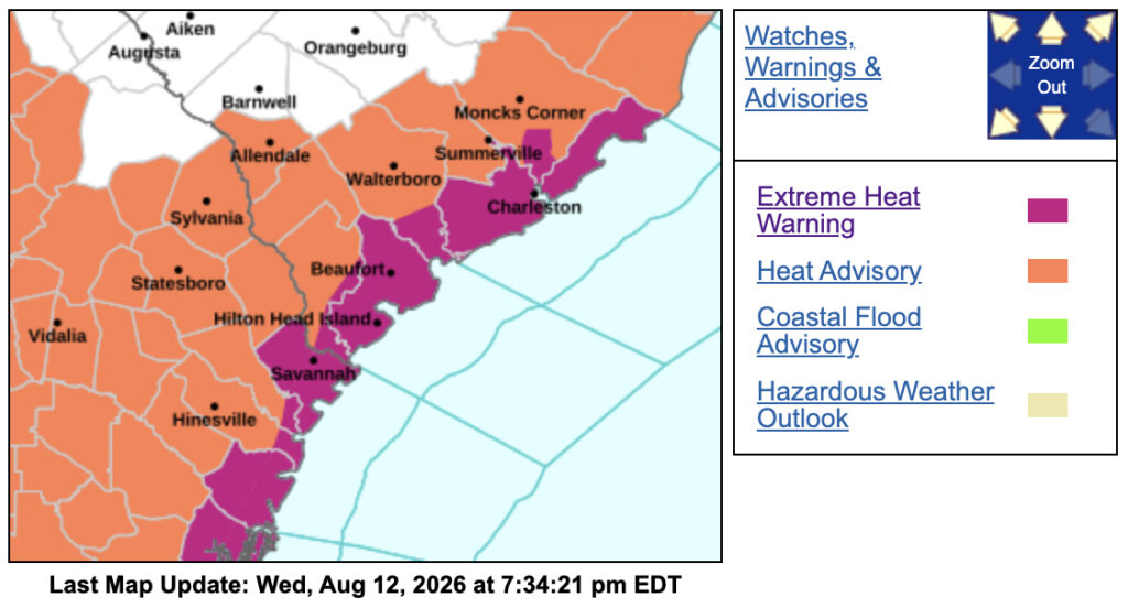
The warning will be in effect from 11 a.m. to 8 p.m., Thursday, Aug. 13.
In its latest update, issued at 7:04 p.m., Wednesday, the National Weather Service said dangerously hot conditions with heat index values of 113 degrees or higher are expected throughout the warning area.
A Heat Advisory that had been in effect Wednesday was canceled Wednesday evening, but the Extreme Heat Warning for Thursday remains in effect.
The Beaufort County Sheriff’s Office warned residents Wednesday that the dangerous heat is expected to continue through the end of the week and into the weekend.
In a weather alert, the Sheriff’s Office said the National Weather Service was forecasting a dangerous stretch of extreme heat, with record-breaking heat possible across the region Thursday and Friday.
Very warm overnight temperatures are also expected to provide little relief from the heat.
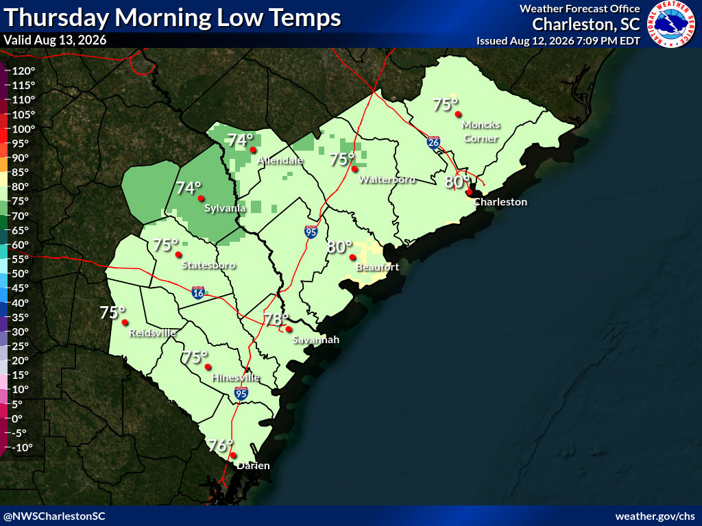
The forecast for Beaufort calls for temperatures in the upper 90s through much of the remainder of the week and weekend, with the heat potentially becoming even more intense early next week.
Temperatures are expected to approach 100 degrees by Monday and Tuesday, extending the period of potentially dangerous heat well beyond Thursday’s warning.
Thunderstorms are possible at times during the stretch, but temperatures are expected to remain hot and humid.
The combination of high temperatures and Lowcountry humidity will make conditions feel considerably hotter than the actual air temperature.
The National Weather Service warned that heat-related illnesses increase significantly during extreme heat and high humidity events.
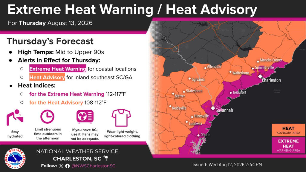
Residents are encouraged to drink plenty of fluids, remain in air-conditioned spaces when possible, stay out of the sun and check on relatives and neighbors.
The Sheriff’s Office is also urging residents not to wait until they feel thirsty to drink water and to limit strenuous outdoor activity, particularly during the hottest part of the day.
Children and pets should never be left inside parked vehicles, even for a short period of time. Pet owners should keep animals hydrated and limit their time on hot pavement.
Those who must work outdoors should take frequent rest breaks in shaded or air-conditioned areas.
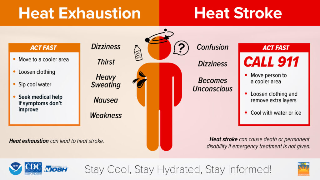
Residents should also know the signs of heat-related illness. Confusion or loss of consciousness can be signs of heat stroke, which is a medical emergency. Anyone experiencing symptoms of heat stroke should be moved to a cooler location and 911 should be called immediately.
Cooling locations available
Beaufort County is directing residents who need relief from the heat to county recreation centers and library branches that can be used as cooling locations during their normal operating hours.
In northern Beaufort County, the Burton Wells Recreation Center is open from 8 a.m. to 8 p.m. Monday through Friday and from 8 a.m. to 4 p.m. Saturday and Sunday.
The Beaufort Branch Library is open from 9 a.m. to 7 p.m. Monday through Thursday and from 9 a.m. to 5 p.m. Friday and Saturday.
The Lobeco Branch Library is open from 10 a.m. to 6 p.m. Monday through Thursday and from 10 a.m. to 5 p.m. Friday and Saturday.
The Port Royal and St. Helena branch libraries are open from 10 a.m. to 7 p.m. Monday through Thursday and from 10 a.m. to 5 p.m. Friday and Saturday.
In southern Beaufort County, the Buckwalter Recreation Center is open from 8 a.m. to 8 p.m. Monday through Friday and from 8 a.m. to 4 p.m. Saturday and Sunday.
The Bluffton and Hilton Head branch libraries are open from 9 a.m. to 7 p.m. Monday through Thursday and from 9 a.m. to 5 p.m. Friday and Saturday.
Forecast at a glance
Thursday, Aug. 13: Extreme Heat Warning from 11 a.m. to 8 p.m. Dangerously hot conditions, with heat index values of 113 degrees or higher expected.
Friday, Aug. 14: Another very hot and humid day, with record-breaking heat possible across the region.
Saturday, Aug. 15: Hot and humid conditions continue into the weekend.
Sunday, Aug. 16: Continued hot and humid conditions with little relief from the prolonged stretch of heat.
Monday, Aug. 17: Temperatures are expected to approach 100 degrees.
Tuesday, Aug. 18: Extreme heat could continue, with temperatures around 100 degrees possible.
Delayna Earley, who joined The Island News in 2022, formerly worked as a photojournalist for The Island Packet/The Beaufort Gazette, as well as newspapers in Indiana and Virginia. She can be reached at delayna.theislandnews@gmail.com.