
By Bill Rauch
The next time a young person asks you what is the business of the future, you might consider telling them “bulkheads.” “Bulkheads are very popular in Beaufort County,” County Planning Director Tony Criscitello told me on Monday.
And they will likely become more popular.
Three low-lying Pacific nations, Kiribati, Tokelau and Tuvalu (within the Marshall Islands), caught the world’s attention last week when their leaders told negotiators at the global warming summit in Paris that they believe their nations will be largely under water by 2090, The Wall Street Journal reported. Their claim was based upon the Australian Bureau of Meteorology’s findings that sea levels will rise by “as much as 87 centimeters (nearly 3 feet) by 2090.”
What does that mean for us? One of the world’s foremost experts on sea level rise, climate scientist Robert Kopp, Associate Professor of Earth and Planetary Sciences at Rutgers University, told me Monday that for a variety of very complicated reasons that include where the Antarctic glaciers are melting fastest and the earth’s orbit and its relationship to the earth’s curvature, sea level rise in Beaufort and the Carolina Lowcountry in the upcoming years will be “slightly above the global average, while the Marshall Islands will be about average.”
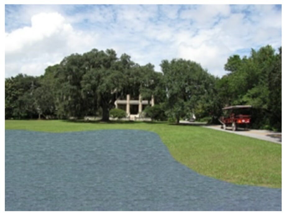
What would three feet of sea level rise mean for Beaufort? To see, go to https://coast.noaa.gov/slr where the National Oceanic and Atmospheric Administration (NOAA) has put up a handy interactive map that shows which lands everywhere in the USA will be underwater at 1-6 feet of sea level rise. The map shows that “The Green” at Pinckney and King Streets would be more than 50% underwater at high tide if the mean sea level were to rise by three feet.
Furthermore, NOAA has been studying the rise in “nuisance flooding.” The agency’s oceanographers have found that the number of days that Charleston has had salt water flooding in its streets rose from 8 in 1960 to 33 in 2014. The 2015 tally isn’t in yet, of course, but with the recent king tides the number won’t be small. NOAA’s September, 2015 nuisance flooding report attributes the rise in flooding in coastal communities around the country to “higher sea levels and more frequent storm surge, compounded by the strengthening El Niño.”
How much have the seas actually risen? “About two inches since the year 2000,” Professor Kopp says. Brady Phillips, a climate expert at NOAA further explained that the recent rise is due almost entirely to the thermal expansion of water at one degree Celsius higher. The effect of the much-publicized melting glaciers has largely not yet been felt, he said.
In 2013, the year after Hurricane Sandy killed 43 New Yorkers and caused $71 billion in property damage, New York Mayor Michael Bloomberg announced the $20 billion “Stronger, More Resilient New York Plan” that took for its premise “We can fight for and rebuild what was lost, fortify the shoreline, and develop waterfront areas for the benefit of all New Yorkers. The city cannot, and will not, retreat.” The plan calls for a variety of measures like bulkheads, elevating low-lying streets and better drainage systems.
Japan too — also in the wake of a natural disaster, in their case the 2011 tsunami that badly damaged the Fukushima Nuclear Facility — has undertaken an aggressive shoreline protection program. Japan’s plan calls for more than 300 miles of seawalls, some several stories high.
No one at Beaufort County was aware last week of any similar grand plans to fortify infrastructure that the county or its municipalities have developed. But one thing’s for sure: like New York and Tokyo, Beaufort County and communities on all three coasts will not retreat. If it comes, they will face the threat.
In a modest way, without formally acknowledging it, the County is doing so already. Eddie Bellamy, Beaufort County’s Public Works Director, the man on the front lines, told me this on Monday: “This global warming, I don’t know what causes it, but I darn sure know it exists. Those king tides we just had, those were higher tides than anybody I work with can remember.”
Bellamy’s present primary focus in the face of salt water flooding, he said, is on keeping the county’s roads above sea level, and on the most low-lying ones he says the county’s been trucking in dirt to get their elevations up.
The last time this happened, Professor Kopp added, was 125,000 years ago. Then, according to the professor’s researches, the Earth was 5 degrees warmer than it is today and the seas were 7-9 meters (22-28 ft.) higher.
That’s a lot of bulkheads that will be built between here and there.